Copyright ©APKPanda. All Rights Reserved
Baixar Geo Survey - v1.1
| Package Name | com.ncbc.survey.gis |
|---|---|
| Category | APLICATIVOS, Mapas e navegação |
| Latest Version | 1.1 |
| Get it On |

|
| Update | February 08, 2021 (4 years ago) |
Você já ouviu falar de Geo Survey - v1.1, ou Hammer Truck GPS Navigation App, Maps, & Routes, Circuit Route Planner, Genius Maps Offline GPS Navigation, Bykea Partner, Lalamove Driver - Earn Extra Income, Radarbot (MOD, Premium Desbloqueada) MOD APK, um dos mais legais APLICATIVOS da categoria Mapas e navegação.
E é claro que você sabe que nem todos os jogos ou aplicativos são compatíveis com todos os telefones. Às vezes, o jogo ou aplicativo não está disponível em seu dispositivo, depende da versão do sistema. Sistema operacional Android, resolução de tela ou países que o Google Play permite acesso. É por isso que o APKPanda fornece arquivos APK do Android para você baixar e não segue essas restrições.>
Geo Survey - v1.1 a versão mais recente é 1.1, data de lançamento 2021-02-07 e tem tamanho 7.9 MB.Desenvolvido por National Center for Big Data and Cloud Computing, Geo Survey - v1.1 requer versão Android de pelo menos Android 4.1+. Portanto, você deve atualizar seu telefone se necessário.
Bastante carregado, cerca de 1000 downloads. Você pode atualizar aplicativos que foram baixados ou instalados individualmente em seu dispositivo Android, se desejar. A atualização de seus aplicativos dá a você permissão de acesso aos recursos mais recentes e melhora a segurança e estabilidade dos aplicativos.
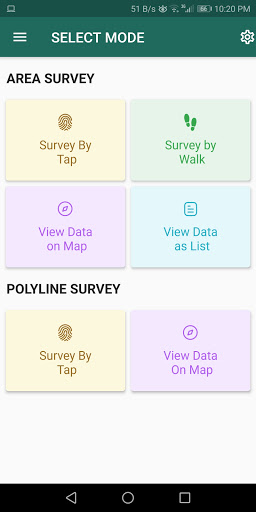
Free application for carrying out GIS survey. This app enables surveyors to collect data (coordinates) of points on a map by creating polygons/poly-lines. This can be done in two ways. First, by walking around the area of interest, or secondly, through manual selection of an area on the map.
Features:
1. Survey can be carried out using any of the two modes:
a. First survey mode (walking mode) can be used by surveyors for collecting several points by walking around the field/land or any region of interest. Polygon will be drawn on the map once survey of field is stopped by the surveyor.
b. Second survey mode (manual selection) can be used by surveyors for collecting several points by tapping on the map. Polygon/poly-line will be drawn on the map once surveyor stops selecting points on the map.
2. Each polygon can be listed under main-category(survey) and subcategory(class) for better organization of survey data.
3. Each polygon can be titled/named separately by surveyor.
4. Data can be viewed by any of two choices:
a. View data on map - Polygons/poly-lines can be viewed on map by selecting a "survey" name and a "class" name.
b. View data without map - Data of polygons can be viewed without map if user does not want to plot polygons on map and only wants to view data of the polygons.
5. Export and Share - Export and share data in json format.
6. Limit Constraint - This free version of app has a limit constraint of creating 20 polygons/poly-lines for any "class" of any "survey". However, new "classes" can be creating for carrying out survey.
7. Cloud storage - Data is stored in and synced with cloud.
- User can now download entire survey(s) data in json format- "Survey by Tap" for polygons, now show the previous polygons drawn by the users. This can now omit the possibility of drawing overlapping polygons.
Show moreRELATED