
Copyright ©APKPanda. All Rights Reserved
您听说过ALTLAS Trails & Maps: Walking trails & Elevation - v3.0.1或Relief Maps - 3D GPS Hiking | Trail Running | Ski, Jugnoo Drivers, Bykea Partner, GPS Emulator Pro APK v1.59 MOD APK, Wikiloc Outdoor Navigation GPS Premium APK MOD APK, Circuit Route Planner,是类别地图和导航中最酷的应用之一。
当然,您知道并非所有游戏或应用程序都兼容所有手机。游戏或应用程序有时在您的设备上不可用,这取决于系统版本。Android操作系统,屏幕分辨率或国家/地区Google Play允许访问。这就是APKPanda提供Android APK文件供您下载且不遵守这些限制的原因。>
ALTLAS Trails & Maps: Walking trails & Elevation - v3.0.1的最新版本为3.0.1,发行日期为2021-10-17,大小为19.6 MB。由Erol1Apps开发,ALTLAS Trails & Maps: Walking trails & Elevation - v3.0.1至少需要Android版本Android 6.0+。因此,如有必要,您必须更新手机。
负载量很大,大约有1000次下载。您可以根据需要更新已单独下载或安装在Android设备上的应用程序。更新应用程序使您可以访问最新功能,并提高应用程序的安全性和稳定性。
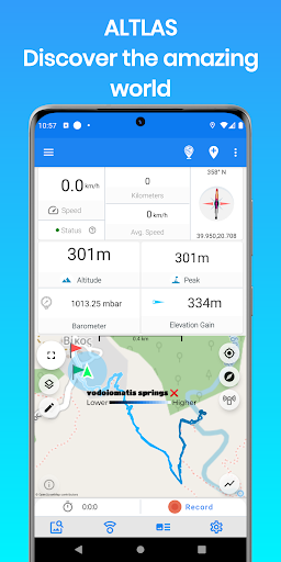
Explore, record, and share your activities, get the current elevation and tracking information with the Altimeter - Activity tracker. Find hiking trails, record your activities with the GPS, Import/export GPX trails.
Download the ultimate activity tool today!
ALT-LAS Can be used as a Bike computer use it on your bike, bicycle, scooter, and more!
By using the app you can get:
1. Elevation finder and activity tracker.
2. The app has a unique database of many trails around the world that was recorded by the users so you get the best hiking trails.
3. The app finds your altitude, peak points, barometric pressure, speed, and more!
4. The app alerts you against altitude limitations and is suitable for a variety of activities such as Walking, Trekking, Flights, Cycling, Skiing, biking, and more.
Have you ever searched for "walks near me?" or find elevation? now you can get it immediately with ALT-LAS.
Help build a community that shares routes and places around the world.
Measuring altitude modes:
1. GPS mode: the application measures the altitude using the GPS and performs a unique correction to provide an accurate altitude.
Note, the altitude readings may be inaccurate when the GPS signal is weak.
2. Barometer sensor (a device with a barometer sensor): the application can work with the device’s barometer sensor that is auto-calibrated with the environment.
In this mode, the application can work inside buildings without GPS.
Features:
- Altimeter to get your current altitude.
- Track activities
- Track your elevation
- Discover and share tracks
- Elevation map
- Compass with lock bearing
- Calories calculator
- Share live location (Subscription only)
- Real-time altitude graph
- Altitude limit alerts
- Save landmarks
- Barometric pressure
- Import/export GPX files
- Climbing information
- The Altimeter can work offline (flight mode)
- Get indoor/outdoors altitude
- Periodic altitude voice notification
- Different map types: Topographic, Open Street Map, hike & bike, and Satellite (Premium only).
- Sensor info (Supported devices only) such as Barometer, Temperature, Light, and Humidity.
- Dark mode
Planning and Navigation tools:
- Measure route and vertical distance
- Routing: get fastest route between any location to another.
- Get coordinates on the map
- Estimate time of arrival
- Circular boundary
SUPPORT:
For any questions or suggestions, feel free to contact us:
Check the Telegram channel where you can ask questions, ideas, request features, share your activities, and more: https://t.me/ALTLASAPP
Customer support:
[email protected]
Website:
www.altlas-app.com
Download the app now and get started!
The use of this app or any of its content is at your own risk.
If you liked the app, please rate it!
ALT-LAS keeps improving with new updates!1. Massive user interface change2. Improve performance 3. Bug fixes.Please let us know what do you think about the new user interface at [email protected]!
Show more