
Copyright ©APKPanda. All Rights Reserved
您听说过GeoTag - v1.4.16或Meitu – Beauty Cam, Easy Photo Editor, Retouch Me – Body editor & Face tune & Skinny app, Pixtica: Camera and Editor, ClipDrop - AR Copy Paste - Pro,
VSCO v256 MOD APK (已解锁 All Pack/VSCO X)
MOD APK, PolyCam Vintage Filters Cam, Aesthetic Leak Effect,是类别摄影中最酷的应用之一。
当然,您知道并非所有游戏或应用程序都兼容所有手机。游戏或应用程序有时在您的设备上不可用,这取决于系统版本。Android操作系统,屏幕分辨率或国家/地区Google Play允许访问。这就是APKPanda提供Android APK文件供您下载且不遵守这些限制的原因。>
GeoTag - v1.4.16的最新版本为1.4.16,发行日期为2020-12-25,大小为62.6 MB。由Andrei Burdenkov开发,GeoTag - v1.4.16至少需要Android版本Android 7.0+。因此,如有必要,您必须更新手机。
负载量很大,大约有1000次下载。您可以根据需要更新已单独下载或安装在Android设备上的应用程序。更新应用程序使您可以访问最新功能,并提高应用程序的安全性和稳定性。
People, please, say your opinion! https://www.facebook.com/geotag.android/ If GeoTag runs properly, please, put a good rating and a comment with wish-features - you will help me to perfect the app!
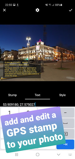
GeoTag was created to geotag the smartphone images with high accuracy (while unable to sync with DSLR cams, GeoTag can add and edit geotags to any offline images stored on your smartphone). This geotagging app allows:
- show and share your current GPS location (or location with all enabled geodata);
- take photos while displaying GPS location and accuracy on the screen,
- add text and voice notes to images;
- share images and display them on the map;
- add and edit GEO-stamps to images and videos:
- edit the GPS coordinates of the image.
Functions might include but not be limited to:
- photographing / geotagging a pothole, a tree or other everyday hazard you want to report on;
- photographing / geotagging a car that was parked against the rules;
- photographing / geotagging your car or bike in a new city / location to come back to it;
- photographing / geotagging a shopping stall at the market you'd like to share with your friend...
Swipe to move between the modes (screens).
Please, note that the time required to obtain GPS coordinates with your smartphone – normally 1-2 minutes - depends on weather, network coverage and other factors like nearby trees, buildings and simply being outdoors. Using the geolocation function of your device along with the camera drains the phone battery.
In detail:
GeoTag can be used outdoors (using indoors reduces GPS accuracy) on smartphones and tabs that support location to take pictures with GPS location data and share them. With GeoTag on your smartphone you can:
in Camera Mode (you enter this mode when you launch the app):
- take pictures while displaying real time coordinates, altitude and accuracy of your location
- geotag pictures - save your coordinates at the time of taking pictures as exif
- jump to the last taken image to enter Image Mode
in Image Mode:
- view images, their coordinates and location on a map (maps: satellite, standard),
- swipe between images from the last taken one to view or delete images and edit comments
- view images full-screen, zoom in and out and add a text or voice comment (please note, that while a text comment becomes a part of the image file stored in exif data and can be shared, a voice note is not added to the file and cannot be shared along with it)
- images can be shared via Picasa, Google Drive … keeping exif data
in Gallery Mode (swipe the camera screen right-to-left to open the Gallery):
- arrange images by name / time of creation
- short-tap an image to enter Image Mode
- long-tap an image icon to edit location.
We are trying to keep it free, please, don't be too harsh when reporting bugs =)
fixed bugsupdated pdf reports
Show moreRELATED