Copyright ©APKPanda. All Rights Reserved
Download Radlkarte Salzburg - v4.0 (31)
| Package Name | at.salzburg.radlkarte |
|---|---|
| Category | APPS, Karten & Navigation |
| Latest Version | 4.0 (31) |
| Get it On |

|
| Update | February 18, 2021 (5 years ago) |
Sie haben von Radlkarte Salzburg - v4.0 (31) oder GPS Emulator Pro APK v1.59 MOD APK,
Sygic GPS Navigation & Maps v20.8.12-1769 APK + MOD (Premium Subscription)
MOD APK, Relief Maps - 3D GPS Hiking | Trail Running | Ski, Wikiloc Outdoor Navigation GPS Premium APK MOD APK, Radarbot (MOD, Premium Entsperrt) MOD APK, Circuit Route Planner gehört, einem der coolsten APPS der Kategorie Karten & Navigation.
Und natürlich wissen Sie, dass nicht alle Spiele oder Anwendungen für alle Telefone kompatibel sind. Das Spiel oder die Anwendung ist manchmal nicht auf Ihrem Gerät verfügbar, dies hängt von der Version des Systems ab. Android-Betriebssystem, Bildschirmauflösung oder Länder Aus diesem Grund bietet APKPanda Android APK-Dateien zum Herunterladen an und hält sich nicht an diese Einschränkungen.>
Radlkarte Salzburg - v4.0 (31) neueste Version ist 4.0 (31), Veröffentlichungsdatum 2021-02-17 und hat Größe 16.6 MB.Für Radlkarte Salzburg - v4.0 (31) entwickelt, erfordert Radlkarte Salzburg - v4.0 (31) mindestens eine Android-Version Android 5.0+. Daher müssen Sie Ihr Telefon bei Bedarf aktualisieren.
Ziemlich geladen, ungefähr 1000 Downloads. Sie können Apps aktualisieren, die einzeln auf Ihr Android-Gerät heruntergeladen oder installiert wurden, wenn Sie möchten. Durch das Aktualisieren Ihrer Apps erhalten Sie Berechtigungszugriff auf die neuesten Funktionen und verbessern die Anwendungssicherheit und -stabilität.
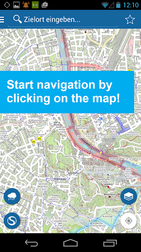
The app turns your smartphone into a GPS bike computer with useful features! Whether you're on your way to work, shopping or simply cycling for fun. The app brings you reliably to your destination.
APP FUNCTIONS:
- An optimized navigation for cyclists
- Easy selection or entry of addresses (starting point, destination point)
- Start your tour by simply clicking on the desired destination on the map
- Display of the last entered start and end points
- Simply add start and finish points to favorites to make them easier and faster to find
- Route: Determination of the recommended and shortest route
- Display of the route on the map
- Route: Display altitude profile, driving time, length, your arrival time and the remaining time and kilometers
- Routing instructions with image and text while driving on the map
- SPECIAL: Voice-guided navigation in German and English
- If there is a route deviation, this will be recalculated immediately
- Most accurate and up to date map and navigation base
- stops and departure monitor (S-Bahn)
- Display precipitation radar
No matter where you are traveling with your bike, you will be navigated as best you can to your destination.
We endeavor to continuously develop and improve the Radlkarte app.
We hope you enjoy cycling and are looking forward to your review.
Wir arbeiten laufend an der Verbesserung dieser App.
Show more