Copyright ©APKPanda. All Rights Reserved
Download Geo Survey - v1.1
| Package Name | com.ncbc.survey.gis |
|---|---|
| Category | APPS, Karten & Navigation |
| Latest Version | 1.1 |
| Get it On |

|
| Update | February 08, 2021 (4 years ago) |
Sie haben von Geo Survey - v1.1 oder Relief Maps - 3D GPS Hiking | Trail Running | Ski, Jugnoo Drivers, Lalamove Driver - Earn Extra Income, Hammer Truck GPS Navigation App, Maps, & Routes, Locus Map Pro Outdoor GPS navigation and maps APK Paid MOD APK, Radarbot (MOD, Premium Entsperrt) MOD APK gehört, einem der coolsten APPS der Kategorie Karten & Navigation.
Und natürlich wissen Sie, dass nicht alle Spiele oder Anwendungen für alle Telefone kompatibel sind. Das Spiel oder die Anwendung ist manchmal nicht auf Ihrem Gerät verfügbar, dies hängt von der Version des Systems ab. Android-Betriebssystem, Bildschirmauflösung oder Länder Aus diesem Grund bietet APKPanda Android APK-Dateien zum Herunterladen an und hält sich nicht an diese Einschränkungen.>
Geo Survey - v1.1 neueste Version ist 1.1, Veröffentlichungsdatum 2021-02-07 und hat Größe 7.9 MB.Für Geo Survey - v1.1 entwickelt, erfordert Geo Survey - v1.1 mindestens eine Android-Version Android 4.1+. Daher müssen Sie Ihr Telefon bei Bedarf aktualisieren.
Ziemlich geladen, ungefähr 1000 Downloads. Sie können Apps aktualisieren, die einzeln auf Ihr Android-Gerät heruntergeladen oder installiert wurden, wenn Sie möchten. Durch das Aktualisieren Ihrer Apps erhalten Sie Berechtigungszugriff auf die neuesten Funktionen und verbessern die Anwendungssicherheit und -stabilität.
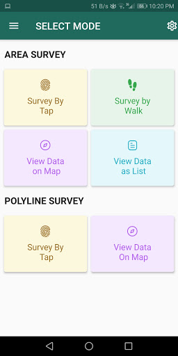
Free application for carrying out GIS survey. This app enables surveyors to collect data (coordinates) of points on a map by creating polygons/poly-lines. This can be done in two ways. First, by walking around the area of interest, or secondly, through manual selection of an area on the map.
Features:
1. Survey can be carried out using any of the two modes:
a. First survey mode (walking mode) can be used by surveyors for collecting several points by walking around the field/land or any region of interest. Polygon will be drawn on the map once survey of field is stopped by the surveyor.
b. Second survey mode (manual selection) can be used by surveyors for collecting several points by tapping on the map. Polygon/poly-line will be drawn on the map once surveyor stops selecting points on the map.
2. Each polygon can be listed under main-category(survey) and subcategory(class) for better organization of survey data.
3. Each polygon can be titled/named separately by surveyor.
4. Data can be viewed by any of two choices:
a. View data on map - Polygons/poly-lines can be viewed on map by selecting a "survey" name and a "class" name.
b. View data without map - Data of polygons can be viewed without map if user does not want to plot polygons on map and only wants to view data of the polygons.
5. Export and Share - Export and share data in json format.
6. Limit Constraint - This free version of app has a limit constraint of creating 20 polygons/poly-lines for any "class" of any "survey". However, new "classes" can be creating for carrying out survey.
7. Cloud storage - Data is stored in and synced with cloud.
- User can now download entire survey(s) data in json format- "Survey by Tap" for polygons, now show the previous polygons drawn by the users. This can now omit the possibility of drawing overlapping polygons.
Show more