Copyright ©APKPanda. All Rights Reserved
Download i-Boating:Marine Navigation Maps & Nautical Charts - v162.0
| Package Name | com.skiracer.nautical_astore_lite |
|---|---|
| Category | APPS, Reisen & Lokales |
| Latest Version | 162.0 |
| Get it On |

|
| Update | December 06, 2020 (5 years ago) |
Sie haben von i-Boating:Marine Navigation Maps & Nautical Charts - v162.0 oder Outdooractive | Welcome home, Patel Tours & Travels, GoPartner, Picap, Webcams Premium APK MOD APK, PeakFinder Mod Extra APK Paid Patched MOD APK gehört, einem der coolsten APPS der Kategorie Reisen & Lokales.
Und natürlich wissen Sie, dass nicht alle Spiele oder Anwendungen für alle Telefone kompatibel sind. Das Spiel oder die Anwendung ist manchmal nicht auf Ihrem Gerät verfügbar, dies hängt von der Version des Systems ab. Android-Betriebssystem, Bildschirmauflösung oder Länder Aus diesem Grund bietet APKPanda Android APK-Dateien zum Herunterladen an und hält sich nicht an diese Einschränkungen.>
i-Boating:Marine Navigation Maps & Nautical Charts - v162.0 neueste Version ist 162.0, Veröffentlichungsdatum 2020-12-03 und hat Größe 24.7 MB.Für i-Boating:Marine Navigation Maps & Nautical Charts - v162.0 entwickelt, erfordert i-Boating:Marine Navigation Maps & Nautical Charts - v162.0 mindestens eine Android-Version Android 4.0+. Daher müssen Sie Ihr Telefon bei Bedarf aktualisieren.
Ziemlich geladen, ungefähr 1000 Downloads. Sie können Apps aktualisieren, die einzeln auf Ihr Android-Gerät heruntergeladen oder installiert wurden, wenn Sie möchten. Durch das Aktualisieren Ihrer Apps erhalten Sie Berechtigungszugriff auf die neuesten Funktionen und verbessern die Anwendungssicherheit und -stabilität.
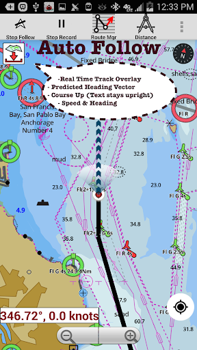
This Marine Charts App offers offline nautical charts, inland river navigation charts, and lake contour maps for kayaking, yachting & sailing.First marine navigation app to have boat route assistance with Voice Prompts. All features of a Marine Chart plotter in one app!It supports Nautical Charts course up orientation. Incl Tide Charts & Currents prediction for nautical navigation. Create new boat routes / Waypoints, or import existing GPX/KML routes on device. Has Marine AIS(NMEA) support.►FEATURES√ GPU accelerated offline vector NOAA charts/ENC charts (text stays upright on rotation)√ Lake depth map shading/safety lake depth contours: customize boat safety depth√ Maritime Aids to Boat Navigation : Beacons,Buoys,Boat Launch areas,Boat Ramps,Marina, Fishing Attractors etc√ Record marine tracks, Autofollow with real-time track overlay√ Voice Prompts for marine navigation√ HD 1ft/3ft depth lake contour maps for anglers for selected lake maps: for fishing/trolling(freshwater/saltwater).√ GPX/KML for boat route.√ Seamless marine chart quilting: Details from Coastal, Approaches,Harbour & Inland ENC (Electronic Marine Charts)√ Waypoints√ Tide & Currents.√ Marine AIS► MAPSAll details of your marine chartplotters!Unlimited updates for 1 year.USA: Maps incl coverage of all NOAA marine charts,ENC,USACE inland river maps & freshwater lake bathymetry maps for more than 20K lakes. Charts incl HD/1ft/3ft bathymetry for selected lakes. Incl NOAA marine charts(rasters) where NOAA ENC coverage isn't available.Canada: CHS data Incl Great lakes(US & Canada sides),Alberta & Ontario lakes,Lake Simcoe&Trent Severn Canal,Quebec reservoirs.UK/Ireland: UKHO marine chartsGermany:BSH charts,Waterways & rivers.FranceEurope Inland Rivers:Donau/Danube/Dunaja,Rhine,Rhein,Garonne,Moselle,Drava,SavaAustraliaNetherland/HollandCroatiaFinlandNorwaySwedenRussiaUkraine(Black Sea)BrazilSpainMalta,Cypress & Mediterranean SeaCaribbeanNew ZealandDenmark,Greenland,FaroeSeychelles,Mauritius,TanzaniaFalklandsMalaysia,South China SeaPersian/Arabian Gulf,Red SeaSouth AfricaArgentinaIcelandFijiEstonia,Latvia,Poland,LithuaniaTurkey,Greece,Italy►Instrumentation√ Marine AIS & (NMEA AIS and GPS over TCP/UDP)√ Wind direction & Speed,Marine Sonar depth,Water temperature►ROUTE MANAGEMENT / TRIP PLANNING√ Create/Edit/Reverse Boat Routes√ Waypoints mgt√ Import GPX,KML & KMZ files√ Share/Export Routes,Boating log, Tracks&Markers►FEATURES for BOAT NAVIGATION√ Auto Follow* Real Time Overlay & Predicted Path Vector* Course Up* Speed & Heading√ Route Assistance With Voice Prompts* approaching boating route marker prompt* Real time nautical distance & ETA* sailing/boating off route/wrong direction √ Record Tracks►TIDE & CURRENTS* High/Low Tides* Tidal Current Prediction* Active Current Stations► SHARING* Sharing of tracks/Boat routes/markers/Waypoints* Export GPX files.► Change background to Satellite Imagery ► USA Marine Charts* Texas Lakes: Texoma,Eufaula,Toledo Bend* California Lakes:Tahoe, Shasta* Pennsylvania Lakes: Lake Raystown* Florida Lakes: Lake Okeechobee,Kissimmee* Minnesota Lakes: Lake Minnetonka,Waconia,Leech,Mille Lacs* Massachussets lakes Quabbin* Missouri Lakes: Truman* Ohio Lake maps of Lake hoover* Wisconsin Lakes: Lake Winnebago,Pepin* Utah Lake Powell,Bear* Maine Lake Sebago* Alaska Lakes: Lake Winnipesaukee* Tennessee Lake Barkley,Norris,Watts Bar* South Carolina Lake Keowee,Hartwell,Murray* Lake Michigan,Huron,Ontario,Superior,Erie► Canada Lakes Maps * Lac Saint Jean* Lake depth maps of Ontario Lakes* Rideau Canal-Ottawa River* British Columbia Marine Charts* Pacific Coast-Vancouver- Haida Gwaii* Nova Scotia South- Bay of Fundy* Quebec to Anticosti Island* Newfoundland* St. Lawrence river* Manitoba & Saskatchewan* Georgian Bay* Puget Sound► UK Nautical Charts* Scotland* Thames Estuary* Ireland► Australia Marine Chars & Lake Maps* NSW * Queensland
-WayPoint Icon-Anchor alarm- Auto Pilot Support-2.5 D (perspective mode)-Greenland-Custom depth shading-Satellite imagery-Water Level Offset-AIS & GPS(NMEA over TCP/UDP)-Russian rivers(Volga)-Instruments:Wind speed,direction,sonar depth,water tempNorway,Finland,South Africa,Netherlands/Holland,Cyprus,DenmarkGerman(Donau,Elbe,Mosel,Neckar,Rhein,Saar,Weser,Westoder)Europe Rivers AustriaBelgium Swiss-RhineGermany-Elbe,Westoder,Ruhr,Mosel,SaarFrance-GRANDE SAONE
Show moreOTHER VERSIONS