Copyright ©APKPanda. All Rights Reserved
Descargar ALTLAS Trails & Maps: Walking trails & Elevation - v3.0.1
| Package Name | altitude.alarm.erol.apps |
|---|---|
| Category | Aplicaciones, Mapas y navegación |
| Latest Version | 3.0.1 |
| Get it On |

|
| Update | October 18, 2021 (4 years ago) |
Has oído hablar de ALTLAS Trails & Maps: Walking trails & Elevation - v3.0.1, o Relief Maps - 3D GPS Hiking | Trail Running | Ski, Locus Map Pro Outdoor GPS navigation and maps APK Paid MOD APK,
Sygic GPS Navigation & Maps v20.8.12-1769 APK + MOD (Premium Subscription)
MOD APK, GPS Emulator Pro APK v1.59 MOD APK, Circuit Route Planner, Hammer Truck GPS Navigation App, Maps, & Routes, uno de los Aplicaciones más interesantes de la categoría Mapas y navegación.
Y, por supuesto, sabes que no todos los juegos o aplicaciones son compatibles con todos los teléfonos. El juego o la aplicación a veces no está disponible en tu dispositivo, depende de la versión del sistema. Sistema operativo Android, resolución de pantalla o países a los que Google Play permite el acceso. Es por eso que APKPanda proporciona archivos APK de Android para que los descargues y no cumple estas restricciones.>
ALTLAS Trails & Maps: Walking trails & Elevation - v3.0.1 la última versión es 3.0.1, la fecha de lanzamiento 2021-10-17 y tiene el tamaño 19.6 MBDesarrollado por Erol1Apps, ALTLAS Trails & Maps: Walking trails & Elevation - v3.0.1 requiere la versión de Android al menos Android 6.0+. Por lo tanto, debe actualizar su teléfono si es necesario.
Casi cargado, sobre 1000 descargas. Si lo desea, puede actualizar las aplicaciones que se han descargado o instalado individualmente en su dispositivo Android. Actualizar sus aplicaciones le da permiso de acceso a las funciones más recientes y mejora la seguridad y estabilidad de las aplicaciones
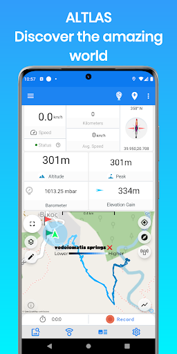
Explore, record, and share your activities, get the current elevation and tracking information with the Altimeter - Activity tracker. Find hiking trails, record your activities with the GPS, Import/export GPX trails.
Download the ultimate activity tool today!
ALT-LAS Can be used as a Bike computer use it on your bike, bicycle, scooter, and more!
By using the app you can get:
1. Elevation finder and activity tracker.
2. The app has a unique database of many trails around the world that was recorded by the users so you get the best hiking trails.
3. The app finds your altitude, peak points, barometric pressure, speed, and more!
4. The app alerts you against altitude limitations and is suitable for a variety of activities such as Walking, Trekking, Flights, Cycling, Skiing, biking, and more.
Have you ever searched for "walks near me?" or find elevation? now you can get it immediately with ALT-LAS.
Help build a community that shares routes and places around the world.
Measuring altitude modes:
1. GPS mode: the application measures the altitude using the GPS and performs a unique correction to provide an accurate altitude.
Note, the altitude readings may be inaccurate when the GPS signal is weak.
2. Barometer sensor (a device with a barometer sensor): the application can work with the device’s barometer sensor that is auto-calibrated with the environment.
In this mode, the application can work inside buildings without GPS.
Features:
- Altimeter to get your current altitude.
- Track activities
- Track your elevation
- Discover and share tracks
- Elevation map
- Compass with lock bearing
- Calories calculator
- Share live location (Subscription only)
- Real-time altitude graph
- Altitude limit alerts
- Save landmarks
- Barometric pressure
- Import/export GPX files
- Climbing information
- The Altimeter can work offline (flight mode)
- Get indoor/outdoors altitude
- Periodic altitude voice notification
- Different map types: Topographic, Open Street Map, hike & bike, and Satellite (Premium only).
- Sensor info (Supported devices only) such as Barometer, Temperature, Light, and Humidity.
- Dark mode
Planning and Navigation tools:
- Measure route and vertical distance
- Routing: get fastest route between any location to another.
- Get coordinates on the map
- Estimate time of arrival
- Circular boundary
SUPPORT:
For any questions or suggestions, feel free to contact us:
Check the Telegram channel where you can ask questions, ideas, request features, share your activities, and more: https://t.me/ALTLASAPP
Customer support:
[email protected]
Website:
www.altlas-app.com
Download the app now and get started!
The use of this app or any of its content is at your own risk.
If you liked the app, please rate it!
ALT-LAS keeps improving with new updates!1. Massive user interface change2. Improve performance 3. Bug fixes.Please let us know what do you think about the new user interface at [email protected]!
Show more