Copyright ©APKPanda. All Rights Reserved
Descargar GeoTag - v1.4.16
| Package Name | travel.minskguide.geotag |
|---|---|
| Category | Aplicaciones, Fotografía |
| Latest Version | 1.4.16 |
| Get it On |

|
| Update | December 25, 2020 (4 years ago) |
Has oído hablar de GeoTag - v1.4.16, o Meitu – Beauty Cam, Easy Photo Editor, Pixtica: Camera and Editor,
VSCO v256 MOD APK (Desbloqueado All Pack/VSCO X)
MOD APK, Camera Pro Control APK v2.6.1 MOD APK, PolyCam Vintage Filters Cam, Aesthetic Leak Effect, FaceApp (MOD, PRO Desbloqueado) MOD APK, uno de los Aplicaciones más interesantes de la categoría Fotografía.
Y, por supuesto, sabes que no todos los juegos o aplicaciones son compatibles con todos los teléfonos. El juego o la aplicación a veces no está disponible en tu dispositivo, depende de la versión del sistema. Sistema operativo Android, resolución de pantalla o países a los que Google Play permite el acceso. Es por eso que APKPanda proporciona archivos APK de Android para que los descargues y no cumple estas restricciones.>
GeoTag - v1.4.16 la última versión es 1.4.16, la fecha de lanzamiento 2020-12-25 y tiene el tamaño 62.6 MBDesarrollado por Andrei Burdenkov, GeoTag - v1.4.16 requiere la versión de Android al menos Android 7.0+. Por lo tanto, debe actualizar su teléfono si es necesario.
Casi cargado, sobre 1000 descargas. Si lo desea, puede actualizar las aplicaciones que se han descargado o instalado individualmente en su dispositivo Android. Actualizar sus aplicaciones le da permiso de acceso a las funciones más recientes y mejora la seguridad y estabilidad de las aplicaciones
People, please, say your opinion! https://www.facebook.com/geotag.android/ If GeoTag runs properly, please, put a good rating and a comment with wish-features - you will help me to perfect the app!
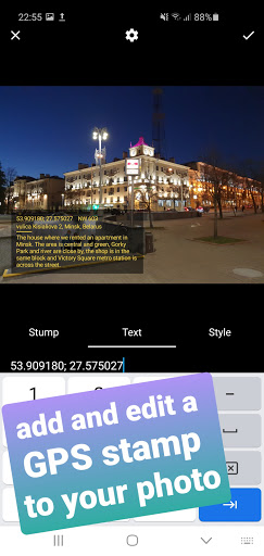
GeoTag was created to geotag the smartphone images with high accuracy (while unable to sync with DSLR cams, GeoTag can add and edit geotags to any offline images stored on your smartphone). This geotagging app allows:
- show and share your current GPS location (or location with all enabled geodata);
- take photos while displaying GPS location and accuracy on the screen,
- add text and voice notes to images;
- share images and display them on the map;
- add and edit GEO-stamps to images and videos:
- edit the GPS coordinates of the image.
Functions might include but not be limited to:
- photographing / geotagging a pothole, a tree or other everyday hazard you want to report on;
- photographing / geotagging a car that was parked against the rules;
- photographing / geotagging your car or bike in a new city / location to come back to it;
- photographing / geotagging a shopping stall at the market you'd like to share with your friend...
Swipe to move between the modes (screens).
Please, note that the time required to obtain GPS coordinates with your smartphone – normally 1-2 minutes - depends on weather, network coverage and other factors like nearby trees, buildings and simply being outdoors. Using the geolocation function of your device along with the camera drains the phone battery.
In detail:
GeoTag can be used outdoors (using indoors reduces GPS accuracy) on smartphones and tabs that support location to take pictures with GPS location data and share them. With GeoTag on your smartphone you can:
in Camera Mode (you enter this mode when you launch the app):
- take pictures while displaying real time coordinates, altitude and accuracy of your location
- geotag pictures - save your coordinates at the time of taking pictures as exif
- jump to the last taken image to enter Image Mode
in Image Mode:
- view images, their coordinates and location on a map (maps: satellite, standard),
- swipe between images from the last taken one to view or delete images and edit comments
- view images full-screen, zoom in and out and add a text or voice comment (please note, that while a text comment becomes a part of the image file stored in exif data and can be shared, a voice note is not added to the file and cannot be shared along with it)
- images can be shared via Picasa, Google Drive … keeping exif data
in Gallery Mode (swipe the camera screen right-to-left to open the Gallery):
- arrange images by name / time of creation
- short-tap an image to enter Image Mode
- long-tap an image icon to edit location.
We are trying to keep it free, please, don't be too harsh when reporting bugs =)
fixed bugsupdated pdf reports
Show more