Copyright ©APKPanda. All Rights Reserved
Descargar VFRnav flight navigation - v3.14.2
| Package Name | com.flugbetrieb.VFRnav |
|---|---|
| Category | Aplicaciones, Mapas y navegación |
| Latest Version | 3.14.2 |
| Get it On |

|
| Update | October 24, 2021 (4 years ago) |
Has oído hablar de VFRnav flight navigation - v3.14.2, o Jugnoo Drivers, Wikiloc Outdoor Navigation GPS Premium APK MOD APK, Lalamove Driver - Earn Extra Income, GPS Emulator Pro APK v1.59 MOD APK, Radarbot (MOD, Premium Desbloqueado) MOD APK, Circuit Route Planner, uno de los Aplicaciones más interesantes de la categoría Mapas y navegación.
Y, por supuesto, sabes que no todos los juegos o aplicaciones son compatibles con todos los teléfonos. El juego o la aplicación a veces no está disponible en tu dispositivo, depende de la versión del sistema. Sistema operativo Android, resolución de pantalla o países a los que Google Play permite el acceso. Es por eso que APKPanda proporciona archivos APK de Android para que los descargues y no cumple estas restricciones.>
VFRnav flight navigation - v3.14.2 la última versión es 3.14.2, la fecha de lanzamiento 2021-10-23 y tiene el tamaño 37.6 MBDesarrollado por flugbetrieb.com, VFRnav flight navigation - v3.14.2 requiere la versión de Android al menos Android 5.0+. Por lo tanto, debe actualizar su teléfono si es necesario.
Casi cargado, sobre 1000 descargas. Si lo desea, puede actualizar las aplicaciones que se han descargado o instalado individualmente en su dispositivo Android. Actualizar sus aplicaciones le da permiso de acceso a las funciones más recientes y mejora la seguridad y estabilidad de las aplicaciones
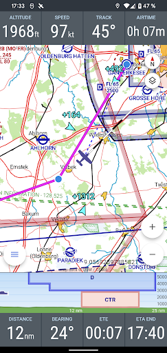
The integrated database includes airfields from Germany, Austria, Switzerland as well as BeNeLux, France, Italy, the Czech Republic and Poland and many other countries with information about name, frequency and runway data.
After the setup, VFRnav works completely offline and does not need an existing data connection for navigation at any time.
The integrated flight planning helps with route planning, the calculation of fuel and flight times and automatically provides information about flight weather (metar & taf) and notams along the route.
The flight log enables the digital recording of your flights. Thanks to the automatic flight time recording, all flights are automatically recorded. Tracks can be exported as KML files and sent by email. Flown routes can thus be easily displayed e.g. on Google Maps.
For high requirements, VFRnav can process position data from external GPS receivers via Wifi or Bluetooth. Traffic data is also processed and displayed directly on the map. VFRnav works with many FLARM and ADS-B devices. Stratux is also supported.
The development of VFRnav takes place in close contact with pilots in europe. In the current version 3, many ideas and suggestions have been implemented that have reached us by e-mail in the past few months. Many thanks at this point for all the feedback.
All functions of VFRnav can be tested without restrictions. If you like VFRnav, you can purchase a license for 49.95 €. You will receive all updates free of charge for one year. After 12 months have expired, the update period can be extended for just 26.80 €. However, VFRnav itself can run indefinitely.
By the way: The license is personal, but not device-specific. If you use several Android devices under the same Google account, the full version is available on all devices (maximum of three devices).
Note: For the map and airspace display, at least 200MB of free storage space must be available. Compatible with devices from Android 5. A minimum resolution of 480x800 pixels is recommended.
Disclaimer of liability: Please note that VFRnav is not an officially approved aid for flight preparation and execution. A guarantee for the correctness and completeness of the data is excluded. Please always check the data displayed with official aviation maps.
v3.14.2New: vertical airspace viewNew: quick map options button addedNew: show notams / metars on mapNew: waypoint online searchmap style improvedsettings improvedbug fixesv3.13.4Fix: OpenAir importNew: Improved altitude correctionNew: support for hillshadingNew: baro altitude supportFix: some bugsv3.11.2New: Setting to disable metar-taf decodingNew: ETE displays remaining time in seconds (90s)New: Info sheet by map double tapNew: Show location in chart screen
Show more