Copyright ©APKPanda. All Rights Reserved
Téléchargement Netherland Topo Maps - v6.3.0
| Package Name | com.atlogis.netherland |
|---|---|
| Category | Applications, Plans et navigation |
| Latest Version | 6.3.0 |
| Get it On |

|
| Update | December 22, 2020 (5 years ago) |
Vous avez entendu parler de Netherland Topo Maps - v6.3.0, ou Genius Maps Offline GPS Navigation, Bykea Partner, GPS Emulator Pro APK v1.59 MOD APK, Radarbot (MOD, Premium Déverrouillé) MOD APK, Relief Maps - 3D GPS Hiking | Trail Running | Ski, Locus Map Pro Outdoor GPS navigation and maps APK Paid MOD APK, l'un des Applications plus cool de la catégorie Plans et navigation.
Et bien sûr, vous savez que tous les jeux ou applications ne sont pas compatibles pour tous les téléphones. Le jeu ou l'application n'est parfois pas disponible sur votre appareil, cela dépend de la version du système. Système d'exploitation Android, résolution d'écran ou pays auxquels Google Play autorise l'accès. C'est pourquoi APKPanda fournit des fichiers APK Android que vous pouvez télécharger et ne respecte pas ces restrictions.>
Netherland Topo Maps - v6.3.0 la dernière version est le 6.3.0, la date de sortie 2020-12-21 et la taille 9.1 MB.Développé par ATLOGIS Geoinformatics GmbH & Co. KG, Netherland Topo Maps - v6.3.0 nécessite au moins la version Android Android 5.0+. Par conséquent, vous devez mettre à jour votre téléphone si nécessaire.
Assez chargé, environ 1000 téléchargements. Vous pouvez mettre à jour les applications qui ont été téléchargées ou installées individuellement sur votre appareil Android si vous le souhaitez. La mise à jour de vos applications vous donne l'autorisation d'accéder aux dernières fonctionnalités et d'améliorer la sécurité et la stabilité des applications.
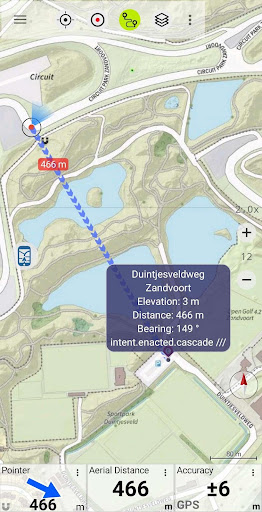
Easy to use Outdoor/Offline GPS navigation app with access to the best topographic maps and satellite images for Netherland.
Turn your Andoid Phone/Tablet into an outdoor GPS for trips into the backcountry WITHOUT CELL COVERAGE. This app gives you similar mapping options as you might know from Garmin or Magellan GPS handhelds.
Included FREE map layers:
• Brtachtergrondkaart from Nationaalgeoregister.nl
• Topo Maps from Nationaalgeoregister.nl
• Orthographic map from Nationaalgeoregister.nl
• OpenStreetMaps : These crowdsourced maps are a very useful addition to other map layers. Contains many unique features.
• OpenCycleMaps: These maps are ideal to plan bicycle trips
• Geological Map (for biologists, geologists, miners, ...)
• ESRI Topographic
• ESRI Aerial Images
• ESRI Street Map
• Google Road Map (online access only)
• Google Satellite Images (online access only)
• Google Terrain Map (online access only)
• Bing Road Map (online access only)
• Bing Satellite Images (online access only)
• Earth At Night
• Hillshading overlay
• OpenSeaMap
Main features for outdoor-navigation:
• Create and edit Waypoints
• GoTo-Waypoint-Navigation
• Track Recording (with speed, elevation and accuracy profile)
• Tripmaster with fields for odometer, average speed, bearing, elevation, etc.
• GPX/KML/KMZ Export
• Search (placenames, POIs, streets)
• Customizable datafields in Map View and Tripmaster (e.g. Speed, Distance, Compass, ...)
• Share Waypoints, Tracks or Routes (via eMail, Whatsapp, Dropbox, Facebook, ..)
• Display coordinates in Lat/Lon, UTM or MGRS/USNG (Military Grid/ US National Grid)
• Record & share tracks with statistics & elevation profile
• Rotate map (Track Up & North Up)
• Get Elevation by long click on map
• Track Replay
• and many more ...
Available Pro features: (Pro features available via In App Purchase)
• Offline Use - no cell coverage needed. No Roaming fees !
• Easy+Fast Bulk-download of map tiles for OFFLINE USAGE (not for Google and Bing maps)
• Create and edit Routes
• Route-Navigation (Point-to-Point Navigation)
• GPX/KML/KMZ Import of Waypoints/Routes/Tracks
• unlimited Waypoints & Tracks
• Add other Map Tile-Server
• No Ads
Offline Use:
All viewed map tiles are kept in cache. To cache large areas you need to purchase Pro features.
Use this navigation app for outdoor activities like hiking, biking, camping, climbing, riding, skiing, canoeing, hunting, offroad 4WD tours or search&rescue (SAR).
Add custom waypoints in longitude/latitude, UTM or MGRS/USNG format with WGS84 datum.
Import/Export/Share GPS-Waypoints/Tracks/Routes in GPX or Google Earth KML/KMZ format.
Preload FREE map data for areas without cell service (Pro feature !).
Comments and feature requests to [email protected]
Have a look at our other outdoor navigation apps: https://play.google.com/store/search?q=atlogis
+++ We DO NOT track any user activities or collect any user data ! +++
• Improvements & Fixes
Show more