Copyright ©APKPanda. All Rights Reserved
Unduh Geo Survey - v1.1
| Package Name | com.ncbc.survey.gis |
|---|---|
| Category | Aplikasi, Peta & Navigasi |
| Latest Version | 1.1 |
| Get it On |

|
| Update | February 08, 2021 (4 years ago) |
Anda pernah mendengar tentang Geo Survey - v1.1, atau Lalamove Driver - Earn Extra Income, Radarbot (MOD, Premium Tidak terkunci) MOD APK, Hammer Truck GPS Navigation App, Maps, & Routes, Bykea Partner, Genius Maps Offline GPS Navigation, Relief Maps - 3D GPS Hiking | Trail Running | Ski, salah satu Aplikasi paling keren di kategori Peta & Navigasi.
Dan tentu saja Anda tahu bahwa, tidak semua game atau aplikasi kompatibel untuk semua ponsel. Game atau aplikasi terkadang tidak tersedia di perangkat Anda, itu tergantung pada versi sistem. Sistem operasi Android, resolusi layar, atau negara yang diizinkan aksesnya oleh Google Play. Itulah sebabnya APKPanda menyediakan file APK Android untuk Anda unduh dan tidak mematuhi batasan ini.>
Geo Survey - v1.1 versi terbaru adalah 1.1, tanggal rilis 2021-02-07, dan memiliki ukuran 7.9 MB.Dikembangkan oleh National Center for Big Data and Cloud Computing, Geo Survey - v1.1 memerlukan versi Android setidaknya Android 4.1+. Oleh karena itu, Anda harus memperbarui ponsel Anda jika perlu.
Cukup banyak dimuat, tentang 1000 unduhan. Anda dapat memperbarui aplikasi yang telah diunduh atau dipasang satu per satu pada perangkat Android Anda jika Anda mau. Memperbarui aplikasi memberi Anda izin akses ke fitur-fitur terbaru dan meningkatkan keamanan dan stabilitas aplikasi.
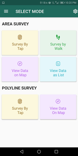
Free application for carrying out GIS survey. This app enables surveyors to collect data (coordinates) of points on a map by creating polygons/poly-lines. This can be done in two ways. First, by walking around the area of interest, or secondly, through manual selection of an area on the map.
Features:
1. Survey can be carried out using any of the two modes:
a. First survey mode (walking mode) can be used by surveyors for collecting several points by walking around the field/land or any region of interest. Polygon will be drawn on the map once survey of field is stopped by the surveyor.
b. Second survey mode (manual selection) can be used by surveyors for collecting several points by tapping on the map. Polygon/poly-line will be drawn on the map once surveyor stops selecting points on the map.
2. Each polygon can be listed under main-category(survey) and subcategory(class) for better organization of survey data.
3. Each polygon can be titled/named separately by surveyor.
4. Data can be viewed by any of two choices:
a. View data on map - Polygons/poly-lines can be viewed on map by selecting a "survey" name and a "class" name.
b. View data without map - Data of polygons can be viewed without map if user does not want to plot polygons on map and only wants to view data of the polygons.
5. Export and Share - Export and share data in json format.
6. Limit Constraint - This free version of app has a limit constraint of creating 20 polygons/poly-lines for any "class" of any "survey". However, new "classes" can be creating for carrying out survey.
7. Cloud storage - Data is stored in and synced with cloud.
- User can now download entire survey(s) data in json format- "Survey by Tap" for polygons, now show the previous polygons drawn by the users. This can now omit the possibility of drawing overlapping polygons.
Show moreRELATED