Copyright ©APKPanda. All Rights Reserved
Scarica Geo Survey - v1.1
| Package Name | com.ncbc.survey.gis |
|---|---|
| Category | App, Mappe e navigatori |
| Latest Version | 1.1 |
| Get it On |

|
| Update | February 08, 2021 (4 years ago) |
Hai sentito parlare di Geo Survey - v1.1, o
Sygic GPS Navigation & Maps v20.8.12-1769 APK + MOD (Premium Subscription)
MOD APK, Circuit Route Planner, Hammer Truck GPS Navigation App, Maps, & Routes, GPS Emulator Pro APK v1.59 MOD APK, Lalamove Driver - Earn Extra Income, Radarbot (MOD, Premium sbloccato) MOD APK, uno dei più interessanti App della categoria Mappe e navigatori.
E ovviamente lo sai, non tutti i giochi o le applicazioni sono compatibili con tutti i telefoni. Il gioco o l'applicazione a volte non è disponibile sul tuo dispositivo, dipende dalla versione del sistema. Sistema operativo Android, risoluzione dello schermo o paesi a cui Google Play consente l'accesso. Ecco perché APKPanda fornisce file APK Android da scaricare e non si attiene a queste restrizioni.>
Geo Survey - v1.1 l'ultima versione è 1.1, data di rilascio 2021-02-07 e dimensione 7.9 MB.Sviluppato da National Center for Big Data and Cloud Computing, Geo Survey - v1.1 richiede almeno la versione Android Android 4.1+. Pertanto è necessario aggiornare il telefono se necessario.
Piuttosto caricato, circa 1000 download. Puoi aggiornare le app che sono state scaricate o installate singolarmente sul tuo dispositivo Android, se lo desideri. L'aggiornamento delle tue app ti dà il permesso di accedere alle funzioni più recenti e migliora la sicurezza e la stabilità delle applicazioni.
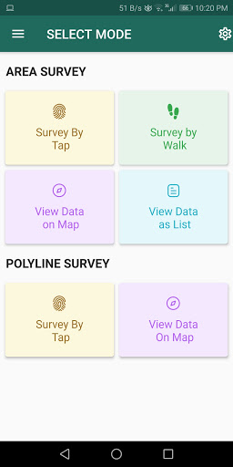
Free application for carrying out GIS survey. This app enables surveyors to collect data (coordinates) of points on a map by creating polygons/poly-lines. This can be done in two ways. First, by walking around the area of interest, or secondly, through manual selection of an area on the map.
Features:
1. Survey can be carried out using any of the two modes:
a. First survey mode (walking mode) can be used by surveyors for collecting several points by walking around the field/land or any region of interest. Polygon will be drawn on the map once survey of field is stopped by the surveyor.
b. Second survey mode (manual selection) can be used by surveyors for collecting several points by tapping on the map. Polygon/poly-line will be drawn on the map once surveyor stops selecting points on the map.
2. Each polygon can be listed under main-category(survey) and subcategory(class) for better organization of survey data.
3. Each polygon can be titled/named separately by surveyor.
4. Data can be viewed by any of two choices:
a. View data on map - Polygons/poly-lines can be viewed on map by selecting a "survey" name and a "class" name.
b. View data without map - Data of polygons can be viewed without map if user does not want to plot polygons on map and only wants to view data of the polygons.
5. Export and Share - Export and share data in json format.
6. Limit Constraint - This free version of app has a limit constraint of creating 20 polygons/poly-lines for any "class" of any "survey". However, new "classes" can be creating for carrying out survey.
7. Cloud storage - Data is stored in and synced with cloud.
- User can now download entire survey(s) data in json format- "Survey by Tap" for polygons, now show the previous polygons drawn by the users. This can now omit the possibility of drawing overlapping polygons.
Show more