
Copyright ©APKPanda. All Rights Reserved
Netherland Topo Maps - v6.3.0 또는 Wikiloc Outdoor Navigation GPS Premium APK MOD APK, Genius Maps Offline GPS Navigation, Jugnoo Drivers, Circuit Route Planner, Radarbot (MOD, Premium 잠금 해제) MOD APK, Locus Map Pro Outdoor GPS navigation and maps APK Paid MOD APK, 지도/내비게이션 카테고리에서 가장 멋진 애플리케이션 중 하나에 대해 들어 보셨습니다.
물론 모든 게임이나 애플리케이션이 모든 휴대 전화와 호환되는 것은 아닙니다. 게임이나 애플리케이션이 기기에서 사용할 수없는 경우도 있으며 시스템 버전에 따라 다릅니다. Android 운영 체제, 화면 해상도 또는 국가 Google Play에서 액세스를 허용합니다. APKPanda는 다운로드 할 수있는 Android APK 파일을 제공하며 이러한 제한을 고수하지 않습니다.>
Netherland Topo Maps - v6.3.0 최신 버전은 6.3.0, 출시일은 2020-12-21이며 크기는 9.1 MB입니다.ATLOGIS Geoinformatics GmbH & Co. KG에서 개발 한 Netherland Topo Maps - v6.3.0는 Android 버전이 Android 5.0+ 이상이어야합니다. 따라서 필요한 경우 휴대 전화를 업데이트해야합니다.
약 1000 회 다운로드했습니다. 원하는 경우 Android 기기에 개별적으로 다운로드하거나 설치된 앱을 업데이트 할 수 있습니다. 앱을 업데이트하면 최신 기능에 대한 액세스 권한이 부여되고 애플리케이션 보안 및 안정성이 향상됩니다.
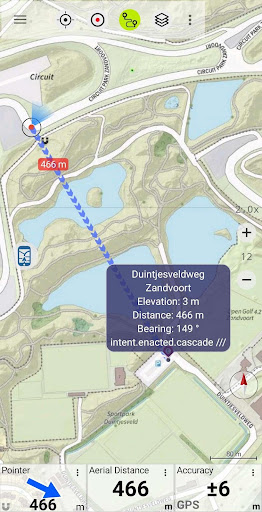
Easy to use Outdoor/Offline GPS navigation app with access to the best topographic maps and satellite images for Netherland.
Turn your Andoid Phone/Tablet into an outdoor GPS for trips into the backcountry WITHOUT CELL COVERAGE. This app gives you similar mapping options as you might know from Garmin or Magellan GPS handhelds.
Included FREE map layers:
• Brtachtergrondkaart from Nationaalgeoregister.nl
• Topo Maps from Nationaalgeoregister.nl
• Orthographic map from Nationaalgeoregister.nl
• OpenStreetMaps : These crowdsourced maps are a very useful addition to other map layers. Contains many unique features.
• OpenCycleMaps: These maps are ideal to plan bicycle trips
• Geological Map (for biologists, geologists, miners, ...)
• ESRI Topographic
• ESRI Aerial Images
• ESRI Street Map
• Google Road Map (online access only)
• Google Satellite Images (online access only)
• Google Terrain Map (online access only)
• Bing Road Map (online access only)
• Bing Satellite Images (online access only)
• Earth At Night
• Hillshading overlay
• OpenSeaMap
Main features for outdoor-navigation:
• Create and edit Waypoints
• GoTo-Waypoint-Navigation
• Track Recording (with speed, elevation and accuracy profile)
• Tripmaster with fields for odometer, average speed, bearing, elevation, etc.
• GPX/KML/KMZ Export
• Search (placenames, POIs, streets)
• Customizable datafields in Map View and Tripmaster (e.g. Speed, Distance, Compass, ...)
• Share Waypoints, Tracks or Routes (via eMail, Whatsapp, Dropbox, Facebook, ..)
• Display coordinates in Lat/Lon, UTM or MGRS/USNG (Military Grid/ US National Grid)
• Record & share tracks with statistics & elevation profile
• Rotate map (Track Up & North Up)
• Get Elevation by long click on map
• Track Replay
• and many more ...
Available Pro features: (Pro features available via In App Purchase)
• Offline Use - no cell coverage needed. No Roaming fees !
• Easy+Fast Bulk-download of map tiles for OFFLINE USAGE (not for Google and Bing maps)
• Create and edit Routes
• Route-Navigation (Point-to-Point Navigation)
• GPX/KML/KMZ Import of Waypoints/Routes/Tracks
• unlimited Waypoints & Tracks
• Add other Map Tile-Server
• No Ads
Offline Use:
All viewed map tiles are kept in cache. To cache large areas you need to purchase Pro features.
Use this navigation app for outdoor activities like hiking, biking, camping, climbing, riding, skiing, canoeing, hunting, offroad 4WD tours or search&rescue (SAR).
Add custom waypoints in longitude/latitude, UTM or MGRS/USNG format with WGS84 datum.
Import/Export/Share GPS-Waypoints/Tracks/Routes in GPX or Google Earth KML/KMZ format.
Preload FREE map data for areas without cell service (Pro feature !).
Comments and feature requests to [email protected]
Have a look at our other outdoor navigation apps: https://play.google.com/store/search?q=atlogis
+++ We DO NOT track any user activities or collect any user data ! +++
• Improvements & Fixes
Show more