
Copyright ©APKPanda. All Rights Reserved
NavShip - Boat Navigation (USA & Europe) - v1.31.1 또는 Circuit Route Planner, Lalamove Driver - Earn Extra Income, Relief Maps - 3D GPS Hiking | Trail Running | Ski, Bykea Partner, Hammer Truck GPS Navigation App, Maps, & Routes,
Sygic GPS Navigation & Maps v20.8.12-1769 APK + MOD (Premium Subscription)
MOD APK, 지도/내비게이션 카테고리에서 가장 멋진 애플리케이션 중 하나에 대해 들어 보셨습니다.
물론 모든 게임이나 애플리케이션이 모든 휴대 전화와 호환되는 것은 아닙니다. 게임이나 애플리케이션이 기기에서 사용할 수없는 경우도 있으며 시스템 버전에 따라 다릅니다. Android 운영 체제, 화면 해상도 또는 국가 Google Play에서 액세스를 허용합니다. APKPanda는 다운로드 할 수있는 Android APK 파일을 제공하며 이러한 제한을 고수하지 않습니다.>
NavShip - Boat Navigation (USA & Europe) - v1.31.1 최신 버전은 1.31.1, 출시일은 2021-02-17이며 크기는 21.5 MB입니다.CproSoft GmbH에서 개발 한 NavShip - Boat Navigation (USA & Europe) - v1.31.1는 Android 버전이 Android 4.1+ 이상이어야합니다. 따라서 필요한 경우 휴대 전화를 업데이트해야합니다.
약 1000 회 다운로드했습니다. 원하는 경우 Android 기기에 개별적으로 다운로드하거나 설치된 앱을 업데이트 할 수 있습니다. 앱을 업데이트하면 최신 기능에 대한 액세스 권한이 부여되고 애플리케이션 보안 및 안정성이 향상됩니다.
Best for inland waterway routing! Please note, that some rivers and seas might not be included yet. Please use the contact form inside the app menu (report error at the bottom) to request a new waterway, and we will implement them as soon as possible.
Free version: Up to 40 km (25 miles) route planning and 8 km tracking. We use advertisement in free version.
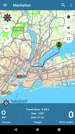
NavShip is a free navigation assistance software for nautic usage in Europe, Canada and the United States. It uses an special overlay for google maps or open sea map to show shipping signs and contains by now more than 250.000 waterways.
No problem to get from A to B, even if there's an ocean between you and your target. London - Rome, Paris - Amsterdam, Copenhagen - Stockholm, Frankfurt - Istanbul, Chicago - Toronto, nearly every route can be calculated.
NavShip needs access to device's storage to work properly. It never accesses your private data or contacts.
WEAR OS: NavShip provides a Wear OS App for Smartwatches. You can easily connect with live routing on your app. Calculate a route on your smartphone and view your current speed, course offset, distance and travel time via smartwatch. Even the next bridge or lock will be displayed.
Features:
Offline-Routing
Live-Routing
Kilometres or miles, km/h or knots
Travel time and distance
Approx. arrival time
Course and speed over ground
Locks
Fuel and costs
Anchor alert
Implementation of own boat icon for routing
Lots of more...
Get more information at www.navship.org
Disclaimer: This app should only be used as an assistant. Please use it carefully and supportive. NavShip is not responsible for accidents. Please note the in app disclaimer and the terms of use at navship.org.
Added side menu entry for privacy policyNew menu entry to swap start and finishCurrents in bodies of water are taken into account if it has been activated in the app settings (currently only for Rhine, Main, Neckar, Mosel, Waal, Lek, IJssel, Maas, Odra, Weser, Elbe, Lahn, Danube and Ems)The app warns when the current of a river is greater than the maximum speed of the boatAdded new compass imageUpdated translations
Show moreRELATED