
Copyright ©APKPanda. All Rights Reserved
GeoTag - v1.4.16 또는
AirBrush v4.17.0 APK + MOD (Premium 잠금 해제)
MOD APK, Retouch Me – Body editor & Face tune & Skinny app, ClipDrop - AR Copy Paste - Pro, Meitu – Beauty Cam, Easy Photo Editor, PolyCam Vintage Filters Cam, Aesthetic Leak Effect, NOMO - Point and Shoot, 사진 카테고리에서 가장 멋진 애플리케이션 중 하나에 대해 들어 보셨습니다.
물론 모든 게임이나 애플리케이션이 모든 휴대 전화와 호환되는 것은 아닙니다. 게임이나 애플리케이션이 기기에서 사용할 수없는 경우도 있으며 시스템 버전에 따라 다릅니다. Android 운영 체제, 화면 해상도 또는 국가 Google Play에서 액세스를 허용합니다. APKPanda는 다운로드 할 수있는 Android APK 파일을 제공하며 이러한 제한을 고수하지 않습니다.>
GeoTag - v1.4.16 최신 버전은 1.4.16, 출시일은 2020-12-25이며 크기는 62.6 MB입니다.Andrei Burdenkov에서 개발 한 GeoTag - v1.4.16는 Android 버전이 Android 7.0+ 이상이어야합니다. 따라서 필요한 경우 휴대 전화를 업데이트해야합니다.
약 1000 회 다운로드했습니다. 원하는 경우 Android 기기에 개별적으로 다운로드하거나 설치된 앱을 업데이트 할 수 있습니다. 앱을 업데이트하면 최신 기능에 대한 액세스 권한이 부여되고 애플리케이션 보안 및 안정성이 향상됩니다.
People, please, say your opinion! https://www.facebook.com/geotag.android/ If GeoTag runs properly, please, put a good rating and a comment with wish-features - you will help me to perfect the app!
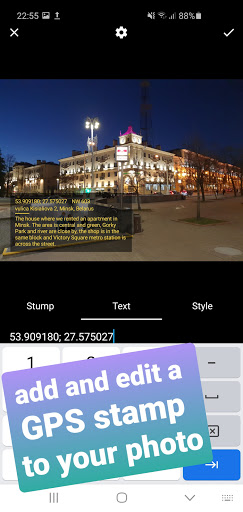
GeoTag was created to geotag the smartphone images with high accuracy (while unable to sync with DSLR cams, GeoTag can add and edit geotags to any offline images stored on your smartphone). This geotagging app allows:
- show and share your current GPS location (or location with all enabled geodata);
- take photos while displaying GPS location and accuracy on the screen,
- add text and voice notes to images;
- share images and display them on the map;
- add and edit GEO-stamps to images and videos:
- edit the GPS coordinates of the image.
Functions might include but not be limited to:
- photographing / geotagging a pothole, a tree or other everyday hazard you want to report on;
- photographing / geotagging a car that was parked against the rules;
- photographing / geotagging your car or bike in a new city / location to come back to it;
- photographing / geotagging a shopping stall at the market you'd like to share with your friend...
Swipe to move between the modes (screens).
Please, note that the time required to obtain GPS coordinates with your smartphone – normally 1-2 minutes - depends on weather, network coverage and other factors like nearby trees, buildings and simply being outdoors. Using the geolocation function of your device along with the camera drains the phone battery.
In detail:
GeoTag can be used outdoors (using indoors reduces GPS accuracy) on smartphones and tabs that support location to take pictures with GPS location data and share them. With GeoTag on your smartphone you can:
in Camera Mode (you enter this mode when you launch the app):
- take pictures while displaying real time coordinates, altitude and accuracy of your location
- geotag pictures - save your coordinates at the time of taking pictures as exif
- jump to the last taken image to enter Image Mode
in Image Mode:
- view images, their coordinates and location on a map (maps: satellite, standard),
- swipe between images from the last taken one to view or delete images and edit comments
- view images full-screen, zoom in and out and add a text or voice comment (please note, that while a text comment becomes a part of the image file stored in exif data and can be shared, a voice note is not added to the file and cannot be shared along with it)
- images can be shared via Picasa, Google Drive … keeping exif data
in Gallery Mode (swipe the camera screen right-to-left to open the Gallery):
- arrange images by name / time of creation
- short-tap an image to enter Image Mode
- long-tap an image icon to edit location.
We are trying to keep it free, please, don't be too harsh when reporting bugs =)
fixed bugsupdated pdf reports
Show moreRELATED