
Copyright ©APKPanda. All Rights Reserved
Biggerworks Nautical Maps - v7.0.0 또는 Webcams Premium APK MOD APK, Outdooractive | Welcome home, Play Disney Parks, Booking.com: Hotels, Apartments & Accommodation, clever-tanken.de, GoPartner, 여행 및 지역정보 카테고리에서 가장 멋진 애플리케이션 중 하나에 대해 들어 보셨습니다.
물론 모든 게임이나 애플리케이션이 모든 휴대 전화와 호환되는 것은 아닙니다. 게임이나 애플리케이션이 기기에서 사용할 수없는 경우도 있으며 시스템 버전에 따라 다릅니다. Android 운영 체제, 화면 해상도 또는 국가 Google Play에서 액세스를 허용합니다. APKPanda는 다운로드 할 수있는 Android APK 파일을 제공하며 이러한 제한을 고수하지 않습니다.>
Biggerworks Nautical Maps - v7.0.0 최신 버전은 7.0.0, 출시일은 2021-01-19이며 크기는 56.3 MB입니다.Biggerworks에서 개발 한 Biggerworks Nautical Maps - v7.0.0는 Android 버전이 Android 6.0+ 이상이어야합니다. 따라서 필요한 경우 휴대 전화를 업데이트해야합니다.
약 1000 회 다운로드했습니다. 원하는 경우 Android 기기에 개별적으로 다운로드하거나 설치된 앱을 업데이트 할 수 있습니다. 앱을 업데이트하면 최신 기능에 대한 액세스 권한이 부여되고 애플리케이션 보안 및 안정성이 향상됩니다.
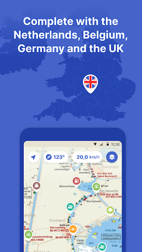
Biggerworks Nautical Maps is the most complete app on the Dutch waters. With ANWB Almanac 2, water maps, marinas, bridges, locks, route planner, offline use and more. Try now and plan your next trip!
With the Nautical Maps app you have everything you need at hand:
• 4 countries, 1 price: Complete nautical maps of the Netherlands, Belgium, Germany and the United Kingdom
• Consult all information from the paper ANWB Water Almanac 2 with just a few taps in the app
• All current information about marinas, bridges and locks including opening times
• Plan the optimal route between your starting point and destination, including the objects you encounter (beta)
• Show or hide information on the nautical maps to see exactly what you need
• Stay up-to-date with the current navigation reports and obstructions from the Rijkswaterstaat
• More than 200,000 nautical objects (bridges, locks, markings, mooring places and more)
• Locations of more than 4,000 marinas and all details of existing facilities
• Radio silence on the water? No problem! Download the corresponding charts for offline use
• Regular updates and free access to all new features
• Each user account can be used on up to 3 devices at no extra cost
• Free Windows version included with the annual subscription
• Reliable service: We are at your service 7 days a week ([email protected])
How the subscription works:
Nautical Maps is free for the first 7 days. After that, the app only works with a valid subscription. You can purchase the following subscriptions:
• Monthly subscription (€ 12.99)
• Seasonal subscription (3 months for just € 29.99)
• Annual subscription including the free Windows version (€ 42.99)
The subscription ends automatically.
Please note: If you purchase a subscription during the free 7-day trial period, the rest of the trial period will expire. Your purchased subscription is not automatically renewed.
Payment methods for subscription
• The subscription will be charged to your Google account
• At Google you can use different payment methods for a subscription, such as PayPal or credit card
Even more boating pleasure with a Nautical Maps account
You can create an account in the app to activate your subscription on a total of 3 devices.
Note:
• The file size of the offline map material is very large and you are advised to download it on a stable Wi-Fi connection.
• Prolonged use of GPS in the background can considerably shorten the battery life of your device.
Do you have questions about the app? Please contact our help desk
([email protected]) or read more on our website (https://www.waterkaarten.app).
The 2021 version of the app is here!-The newest nautical maps with the latest information-Improved performance, the app is now faster and more stable-Improved routeplanner-The POI details are completely overhauled: now with reviews, photos and tips-New POIs: restaurants-Premium POIs-New information and data corrections-Several bug fixesWe wish all of our users a pleasant boating experience with the new version of Nautical maps. The most complete app to boat safely on the waterways.
Show moreOTHER VERSIONS
RELATED