
Copyright ©APKPanda. All Rights Reserved
2GIS: Offline map & Navigation - v5.49.1.383.19 또는 Circuit Route Planner, Radarbot (MOD, Premium 잠금 해제) MOD APK, Lalamove Driver - Earn Extra Income, Relief Maps - 3D GPS Hiking | Trail Running | Ski, Locus Map Pro Outdoor GPS navigation and maps APK Paid MOD APK, Genius Maps Offline GPS Navigation, 지도/내비게이션 카테고리에서 가장 멋진 애플리케이션 중 하나에 대해 들어 보셨습니다.
물론 모든 게임이나 애플리케이션이 모든 휴대 전화와 호환되는 것은 아닙니다. 게임이나 애플리케이션이 기기에서 사용할 수없는 경우도 있으며 시스템 버전에 따라 다릅니다. Android 운영 체제, 화면 해상도 또는 국가 Google Play에서 액세스를 허용합니다. APKPanda는 다운로드 할 수있는 Android APK 파일을 제공하며 이러한 제한을 고수하지 않습니다.>
2GIS: Offline map & Navigation - v5.49.1.383.19 최신 버전은 5.49.1.383.19, 출시일은 2021-10-29이며 크기는 98.7 MB입니다.DoubleGIS, LLC에서 개발 한 2GIS: Offline map & Navigation - v5.49.1.383.19는 Android 버전이 Android 6.0+ 이상이어야합니다. 따라서 필요한 경우 휴대 전화를 업데이트해야합니다.
약 1000 회 다운로드했습니다. 원하는 경우 Android 기기에 개별적으로 다운로드하거나 설치된 앱을 업데이트 할 수 있습니다. 앱을 업데이트하면 최신 기능에 대한 액세스 권한이 부여되고 애플리케이션 보안 및 안정성이 향상됩니다.
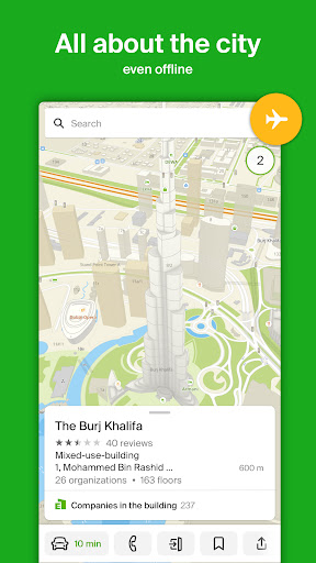
2GIS is a directory with a map and navigator. The application works without Internet connection — download the city database and use it on the plane, subway, or when in a roaming zone.
SERVICES, ADDRESSES, AND COMPANIES
2GIS knows which provider operates in your house, where there is a district hospital or a post office. Will help you to choose a cafe or a service center by reviews and photos. Will show the opening hours and the telephone number.
TRANSPORT AND NAVIGATION
If you are driving, 2GIS will guide you along the road and warn you about the maneuvers using the voice instructions. Will take traffic jams and blocked streets into account. Will update the route if you deviate from your way. For pedestrians, it will find the options of going by buses, metro, trains, cable cars and river trams.
BUILDING ENTRANCES
In order not to look for an entrance to a business center you need, look in 2GIS. The application knows how to enter into 2.5 million companies. If you are looking for route directions for public transport or a car, 2GIS will show the way to the very door.
PLANS OF SHOPPING CENTRES
2GIS helps to navigate inside shopping centers. Shows everything: from shops and cafes to ATMs and toilets. Find places in advance to save time.
CITIES OF THE UAE, CYPRUS, THE CZECH REPUBLIC, CHILE
Dubai, Limassol, Nicosia, Padua, Prague (Praha), Santiago.
CITIES OF RUSSIA
Moscow, Saint Petersburg, Novosibirsk, Ekaterinburg, Krasnoyarsk, Chelyabinsk, Ufa, Omsk, Kazan, Perm and much more! See the full list: https://2gis.ru/countries/global/
CITIES OF UKRAINE, KAZAKHSTAN AND KYRGYZSTAN
Almaty, Nur-Sultan, Kiev, Bishkek and much more.
SOCIAL NETWORKS
Facebook — http://facebook.com/2GISUAE
VKontakte — https://vk.com/2gis
Twitter — http://twitter.com/2gis
Technical support — [email protected]
Breaking news: we have completely revamped the car navigator! Brand new design, a mini-map of the route, parking lots on the map, travel time and arrival time displayed together. Also, we made a lot of algorithm improvements. Go to the application settings, select "Navigator", and turn on the new 2GIS navigator. And don't forget to share your opinion on the update.
Show moreOTHER VERSIONS
- 2GIS: Offline map & Navigation - v5.49.0.382.28
- 2GIS: Offline map & Navigation - v5.49.0.381.20
- 2GIS: Offline map & Navigation - v5.49.0.380.17
- 2GIS: Offline map & Navigation - v5.47.2.371.4
- 2GIS: Offline map & Navigation - v5.46.0.366.10
- 2GIS: Offline map & Navigation - v5.0.8.297.13
- 2GIS: Offline map & Navigation - v5.0.2.276.18
- 2GIS: Offline map & Navigation - v4.3.9.2453
- 2GIS: Offline map & Navigation - v4.3.10.2481