Copyright ©APKPanda. All Rights Reserved
Скачать Geo Survey - v1.1
| Package Name | com.ncbc.survey.gis |
|---|---|
| Category | приложения, Карты и навигация |
| Latest Version | 1.1 |
| Get it On |

|
| Update | February 08, 2021 (4 years ago) |
Вы слышали об Geo Survey - v1.1 или Lalamove Driver - Earn Extra Income, Bykea Partner, GPS Emulator Pro APK v1.59 MOD APK, Circuit Route Planner, Wikiloc Outdoor Navigation GPS Premium APK MOD APK, Relief Maps - 3D GPS Hiking | Trail Running | Ski, одном из самых крутых приложения в категории Карты и навигация.
И, конечно, вы знаете, что не все игры или приложения совместимы со всеми телефонами. Игра или приложение иногда недоступны на вашем устройстве, это зависит от версии системы. Операционная система Android, разрешение экрана или страны доступ к которым разрешен в Google Play. Вот почему APKPanda предоставляет вам файлы APK для Android и не придерживается этих ограничений.>
Geo Survey - v1.1 последняя версия - 1.1, дата выпуска 2021-02-07, размер 7.9 MBРазработано National Center for Big Data and Cloud Computing, Geo Survey - v1.1 требует версии Android не ниже Android 4.1+. Поэтому при необходимости вы должны обновить свой телефон.
«Довольно загружено, около 1000 загрузок. Вы можете обновлять приложения, которые были загружены или установлены индивидуально на вашем устройстве Android, если хотите. Обновление ваших приложений дает вам доступ к последним функциям и повышает безопасность и стабильность приложений».
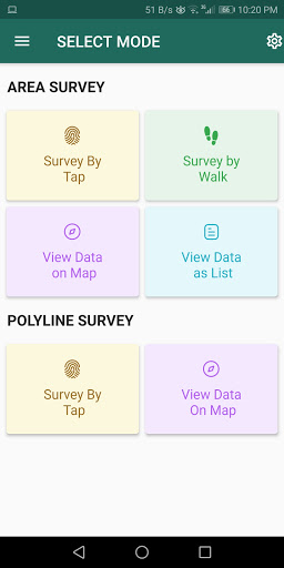
Free application for carrying out GIS survey. This app enables surveyors to collect data (coordinates) of points on a map by creating polygons/poly-lines. This can be done in two ways. First, by walking around the area of interest, or secondly, through manual selection of an area on the map.
Features:
1. Survey can be carried out using any of the two modes:
a. First survey mode (walking mode) can be used by surveyors for collecting several points by walking around the field/land or any region of interest. Polygon will be drawn on the map once survey of field is stopped by the surveyor.
b. Second survey mode (manual selection) can be used by surveyors for collecting several points by tapping on the map. Polygon/poly-line will be drawn on the map once surveyor stops selecting points on the map.
2. Each polygon can be listed under main-category(survey) and subcategory(class) for better organization of survey data.
3. Each polygon can be titled/named separately by surveyor.
4. Data can be viewed by any of two choices:
a. View data on map - Polygons/poly-lines can be viewed on map by selecting a "survey" name and a "class" name.
b. View data without map - Data of polygons can be viewed without map if user does not want to plot polygons on map and only wants to view data of the polygons.
5. Export and Share - Export and share data in json format.
6. Limit Constraint - This free version of app has a limit constraint of creating 20 polygons/poly-lines for any "class" of any "survey". However, new "classes" can be creating for carrying out survey.
7. Cloud storage - Data is stored in and synced with cloud.
- User can now download entire survey(s) data in json format- "Survey by Tap" for polygons, now show the previous polygons drawn by the users. This can now omit the possibility of drawing overlapping polygons.
Show more