Copyright ©APKPanda. All Rights Reserved
Tải về Geo Survey - v1.1
| Package Name | com.ncbc.survey.gis |
|---|---|
| Category | Ứng dụng, Bản đồ & Dẫn đường |
| Latest Version | 1.1 |
| Get it On |

|
| Update | February 08, 2021 (4 years ago) |
Bạn đã từng nghe về Geo Survey - v1.1, hay Jugnoo Drivers, Wikiloc Outdoor Navigation GPS Premium APK MOD APK, Lalamove Driver - Earn Extra Income, Genius Maps Offline GPS Navigation, Relief Maps - 3D GPS Hiking | Trail Running | Ski, Locus Map Pro Outdoor GPS navigation and maps APK Paid MOD APK, một trong những Ứng dụng tuyệt vời của thể loại Bản đồ & Dẫn đường.
Và tất nhiên bạn biết rằng, không phải trò chơi hoặc ứng dụng nào cũng tương thích cho tất cả các điện thoại. Trò chơi hoặc ứng dụng đôi khi không khả dụng với thiết bị của bạn, nó phụ thuộc vào phiên bản hệ điều hành Android, độ phân giải màn hình hoặc các quốc gia mà Google Play cho phép truy cập. Đó là lý do tại sao APKPanda cung cấp các tệp Android APK để bạn tải xuống và không dính vào các hạn chế này.
Geo Survey - v1.1 phiên bản mới nhất là 1.1, ngày phát hành 2021-02-07, và có dung lượng 7.9 MB.Phát triển bởi National Center for Big Data and Cloud Computing, Geo Survey - v1.1 cần bản Android tối thiểu là Android 4.1+. Do đó bạn phải cập nhật điện thoại của mình nếu cần thiết.
Được tải khá nhiều, khoảng 1000 lượt tải được. Bạn có thể cập nhật các ứng dụng đã được tải xuống hoặc cài riêng lẻ trên thiết bị Android nếu bạn muốn. Cập nhật ứng dụng của bạn cung cấp cho bạn quyền truy cập vào các tính năng mới nhất và cải thiện tính bảo mật và ổn định của ứng dụng.
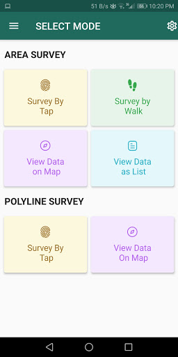
Free application for carrying out GIS survey. This app enables surveyors to collect data (coordinates) of points on a map by creating polygons/poly-lines. This can be done in two ways. First, by walking around the area of interest, or secondly, through manual selection of an area on the map.
Features:
1. Survey can be carried out using any of the two modes:
a. First survey mode (walking mode) can be used by surveyors for collecting several points by walking around the field/land or any region of interest. Polygon will be drawn on the map once survey of field is stopped by the surveyor.
b. Second survey mode (manual selection) can be used by surveyors for collecting several points by tapping on the map. Polygon/poly-line will be drawn on the map once surveyor stops selecting points on the map.
2. Each polygon can be listed under main-category(survey) and subcategory(class) for better organization of survey data.
3. Each polygon can be titled/named separately by surveyor.
4. Data can be viewed by any of two choices:
a. View data on map - Polygons/poly-lines can be viewed on map by selecting a "survey" name and a "class" name.
b. View data without map - Data of polygons can be viewed without map if user does not want to plot polygons on map and only wants to view data of the polygons.
5. Export and Share - Export and share data in json format.
6. Limit Constraint - This free version of app has a limit constraint of creating 20 polygons/poly-lines for any "class" of any "survey". However, new "classes" can be creating for carrying out survey.
7. Cloud storage - Data is stored in and synced with cloud.
- User can now download entire survey(s) data in json format- "Survey by Tap" for polygons, now show the previous polygons drawn by the users. This can now omit the possibility of drawing overlapping polygons.
Show more