
Copyright ©APKPanda. All Rights Reserved
Tải về GPSLogger II - AIO - v2.0.0.159
| Package Name | com.emacberry.gpslogger |
|---|---|
| Category | Ứng dụng, Sức khỏe & thể hình |
| Latest Version | 2.0.0.159 |
| Get it On |

|
| Update | February 06, 2021 (5 years ago) |
Bạn đã từng nghe về GPSLogger II - AIO - v2.0.0.159, hay Fastic: Fasting App & Intermittent Fasting Tracker, Peloton - at home fitness, COVID Alert - Let’s protect each other, Period Tracker Flo, Ovulation Calendar & Pregnancy Premium APK v4.34.1 MOD APK, Hello Haylou Premium APK MOD APK, Wearfit Pro, một trong những Ứng dụng tuyệt vời của thể loại Sức khỏe & thể hình.
Và tất nhiên bạn biết rằng, không phải trò chơi hoặc ứng dụng nào cũng tương thích cho tất cả các điện thoại. Trò chơi hoặc ứng dụng đôi khi không khả dụng với thiết bị của bạn, nó phụ thuộc vào phiên bản hệ điều hành Android, độ phân giải màn hình hoặc các quốc gia mà Google Play cho phép truy cập. Đó là lý do tại sao APKPanda cung cấp các tệp Android APK để bạn tải xuống và không dính vào các hạn chế này.
GPSLogger II - AIO - v2.0.0.159 phiên bản mới nhất là 2.0.0.159, ngày phát hành 2021-02-03, và có dung lượng 10.4 MB.Phát triển bởi Matthias Marquardt, GPSLogger II - AIO - v2.0.0.159 cần bản Android tối thiểu là Android 4.0+. Do đó bạn phải cập nhật điện thoại của mình nếu cần thiết.
Được tải khá nhiều, khoảng 1000 lượt tải được. Bạn có thể cập nhật các ứng dụng đã được tải xuống hoặc cài riêng lẻ trên thiết bị Android nếu bạn muốn. Cập nhật ứng dụng của bạn cung cấp cho bạn quyền truy cập vào các tính năng mới nhất và cải thiện tính bảo mật và ổn định của ứng dụng.
The all in one GPS Tracking and offline Map solution - all for free & without in app advertisements
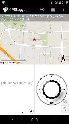
GPSLogger II is a pretty straightforward application that can record your GPS based location over the time. Initially developed for the BlackBerry platform (started 2009) the functionality have grown constantly over the time. Even this is the first release for Android you can expect an package that is suitable for all kind of activities, include outdoor navigation, geo-caching or an easy to use car finder.
Beside the actual position (in WGS84) the application will record the time, speed, heading/course, altitude, accuracy (of the signal), number of satellites and (if enabled) the raw NMEA-data.
GPSLogger comes with plenty of settings which should allow you to adjust the application to your personal likings, starting with the selection between imperial, metric or nautical units or different location formats [DD.MM'ss.ms", DD.MMMMM, UTM (+Zone), MGRS or raw mode]. The speed can be toggled between km/h or 'Minutes per KM' (of course also as mph and Minutes per Mile).
There are ten different views (up to three of them can be displayed simultaneously) Each view have a specific use case and allows you to adjust the display information to your personal needs. You simply can switch between the different views by swiping left or right.
- OpenMapData View
Currently the following OpenMapData providers are supported: MapQuest OSM, MapQuest Open Aerial, Bing Maps|Satellite|Hybrid, esri World Street Map, esri World Topographic Map, OpenCycleMap, Outdoor (by OCM) and Landscape (by OCM) - also you can specify a custom tile-server URL, so you could just add your preferred local map data provider (please check the corresponding tile server usage policy).
Please note, that GPSLogger will request the map data only once - so it can work completely OFFLINE once that map data has been stored on your device (an additional free DesktopTool is also available).
- Path View
When you have no data connection (or have configured GPSLogger that no data should be transferred) the path view is a simply plot of your current logging path (or the navigation path - or the path data that you have loaded in the background)
- Direction View
By default your logging starting point will be the initial direction record. The Direction view points you into the direction of this navigation location and display all kind of additional information like the estimated time of arrival (based on your current speed/average speed), the relative speed to the target location (very useful for sailing) and of course the course to the target location.
When you are using GPSLogger for outdoor navigation the direction record will change dynamically based on your travelling progress and your specified outdoor navigation settings.
- Speed View, Elevation View, Compass View
Simple plot of your Speed/Elevation values over time and a Compass
- GPS CoreData View
Displaying the location and the current speed and course in the largest possible font on your device
The remaining other 3 views Navigation Direction, Navigation GPS Core Data and the Navigation Speed can be very useful when you make use of the extended outdoor navigation functionality - actually I have implemented them for my personal usage when I am riding with the MTB. See http://www.emacberry.com/gpsl/nav/nav002.html for details.
Core Functions:
======================
o GPSLogger
o Speedometer
o CarFinder
o Outdoor Navigation
o GeoCaching and Waypoint Management
o AutoEmergency Alert
o Import and Export of KML or GPX
o 100% OFFLINE
o Support for "Shimano Di2®"
REQUIREMENTS
======================
o An Android® device with a build in GPS Antenna (or a active & already paired Bluethooth GPS-Puck)
o Use GPSLogger II outdoors - The reception of the GPS signal inside a building can be very bad or even not available at all.
o Permission
Feedback & Support via our Forum @ http://forum.emacberry.com/viewforum.php?f=198
- Elevation enhancements & more- Render 15km Radius around locations- Custom Di2 Crankset & Cassette Configuration- Performance enhancements- Supporting alternative TextToSpeech Engines (TTS) like FLite- VTM & Mapsforge Lib updated- added in App Privacy Policy
Show more